Return to Home Page
Return to Hewins Creek Map
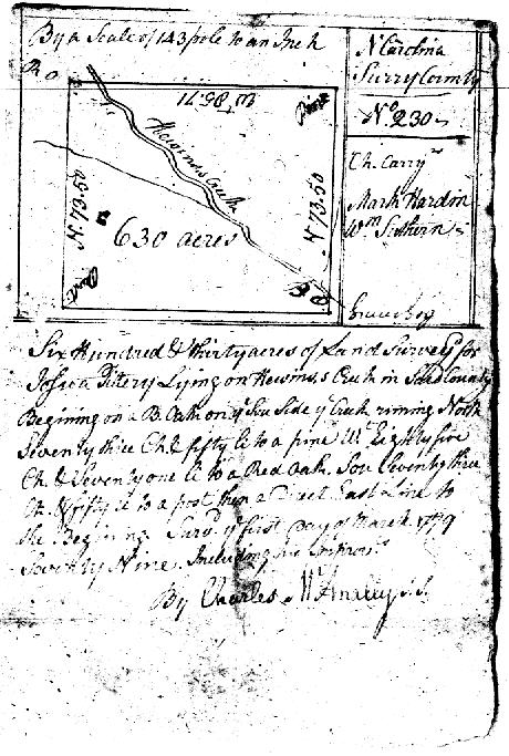
The image below is a scan of a photocopy of the original surveyor's plat drawn by Charles McAnally for a land grant of 630 acres (almost one square mile) entered for Joshua Tillery on October 5, 1778. A second grant for Tillery of 300 acres along the north side of this grant was entered in April 1780. William Southern was a chain carrier for both surveys. Tillery sold the western half of the first grant to William Southern in 1782. Since the deed mentions William Southern's improvements, Southern had occupied the land for some time before the sale. William's son Reuben later acquired (in stages) the eastern half of this grant and the 300 acre grant on the north.
Joshua Tillery apparently never resided in Surry or Stokes County, N.C. Another researcher reports that he married Susannah Zeigler about 1770 in Culpepper County, Virginia, and ultimately settled in north Georgia. The Southerns' Stokes County associations with the Zimmermans and other families originally from Culpepper may suggest a social connection. But the exact nature of Tillery's business or personal relationship to the Southern family is not known. Reuben Southern named his eldest son Joshua, which might suggest more than a business relationship to Tillery.
These plats make reference to surrounding grants made along Hewins Creek about the same time that were also surveyed by Charles McAnally. Pieced together, the plats show almost the full length of Hewins Creek down to the Dan River, a section of which is shown in the southeasternmost grant. Redrawn to modern USGS map scale, the plats make a remarkably good fit over the modern map.