Return to Home Page
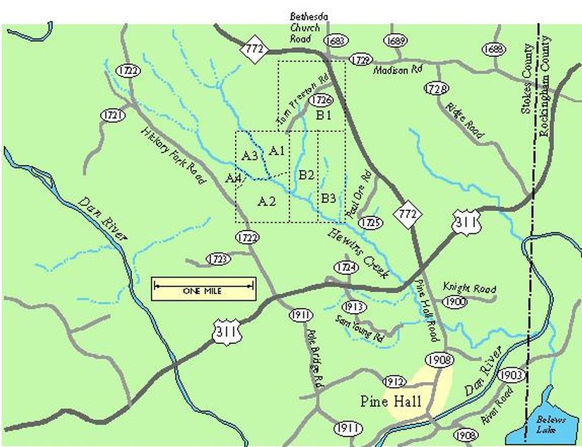
Southern Family Farms on Hewins Creek, Stokes County, N.C., in the late 18th Century
This map shows the two state land grants of 630 and 300 acres to Joshua Tillery made in 1778 and 1780, and purchased by William Southern and Reuben Southern in 1782 and 1789.
See scan of the original 1778 survey of the land grant to Joshua Tillery that became the Southern farms.
See also Photographs along Hewins Creek I made in 1998.
Boundaries are approximate, considering these are 18th century surveys superimposed over a modern map, but the general layout should be correct.
A1 through A4, and B2 and B3: Original grant of 630 acres (in actuality I think a little less) to Joshua Tillery, entered 10/5/1778.
B1: Tillery's second grant of 300 acres, entered 4/15/1780.
A1 through A4: Tillery to William Southern, 7/13/1782. 315 acres. Book B, p. 181 (Surry County; all other deeds Stokes County).
B1 and B2: Tillery to Reuben Southern, 3/2/1789. 457 1/2 acres. Book 1, p. 14.
B3: Tillery to Elisha Thomas, 3/8/1789. 157 1/2 acres. Book 1, p. 53 Thomas to John Webster, 1/10/1791. 157 1/2 acres. Book 1, p. 85 Webster to Reubin Zimmerman, 1/23/1794. Less 30 acres -- 127 1/2 total. Book 2, p. 160. "Zimimon" to Reubin Southern, 9/24/1796. 127 1/2 acres. Book 2, p. 337.
A3: William to son John, "in the fork of the creek," 5/13/1794. 75 acres m/l. Book 2, p. 112.
A2 and A4: William and Magdalen Southern to son Ford, 8/1/1790. Book 1, p. 53. 155 acres. Ford to Joseph Burch, 11/20/1803. Here surveyed as 147 acres. Book 4, p. 304.
A4: Joseph Burch to John Southern. 2/1/1804. 15 acres. Bk 4, p. 336
A2: Joseph Burch to John Bostick, 2/1/1804. 130 acres. Bk 4, p. 342. I haven't followed A2 past Bostick.
A1, A3, and A4: John and Elizabeth Southern to John Terry. 1/4/1817. 3 tracts of 15,75, and 75 acres, "being the a part of the said John Southerns fathers land whereon ...the said William Southern lived and died." Terry sold the same tract the same year (for the same amount) to Peter Hairston, the richest landowner inthe area (Bk 6, p. 63).
B1, B2, and B3: Reuben's land. Reuben also later purchased a couple of smaller tracts to the east. One of these later tracts contained a "meeting house." This land has a complex history of sales from Reuben to his sons. Most was sold out of the family by the 1830s, some of it at least to Peter Hairston.
Click here to see photographs taken in April, 1998 in sections A1, A2, and B2 along the creek.